Errachidia province in Morocco : complete guide
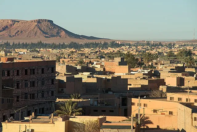
Located at 1010 meters above sea level in an arid area at the foot of the Atlas, it is the ancient city of Ksar Es-Souk. Inhabited by the Aït Yafelmane tribe, it served as a base for the French Foreign Legion during the French protectorate until 1956.
It was built in the early twentieth century, in the military style, with straight and well-urbanized streets.
It is located on the Ziz River, which brings water from the melting ice of the Atlas and forms a pond. This river dies a little further south, in the Sahara.
Today, it is the capital of the Tafilalet region as well as an important administrative, commercial, military, and academic center.
Its valleys are part of the oases of southern Morocco declared a World Heritage Site and there is an abundance of geological and mineral deposits where date palms are grown.
All the traditional architecture of the area is based on the principle of fortification.
The kasbah or Tighremt is a multi-story building that has towers at its four corners and, sometimes, a central patio.
The alcazar (ksar or Ighrem) is a village surrounded by walls with surveillance towers at different points and one or more monumental entrances. Inside, in addition to the houses, there is always a mosque, a space for parties, and sometimes, an inn (Fondouk).
The climate is desert, with cold winters (temperatures fall below zero) and very hot summers (40°). The best seasons are spring and autumn.
Errachidia has a small airport with regular flights to Casablanca and
charter flights. It is a base and departure city for desert tourism, towards
the dunes of Merzouga, Erfoud, Rissani, the Kasbahs road, the Atlas, or the
Rekkan plateau, with garages for all-terrain vehicles.
Note the pond of
Moulay Hassan Eddakhil. With the contrast between the blue of its waters and
the ochre color of the mountains, this place is a very beautiful site. It is
also a break area for migratory birds and angling enthusiasts use it a lot.
The gorges of El Kheng are also worth a visit.
Near the pond is Ksar Jdid Lake, an old sand mine.
In May, the Desert Music Festival is celebrated throughout the Tafilalet region. It lasts a week and artists from Arabia and Africa are present.
Handicraft
In the region, a ceramic characterized by the absence of ornamental paintings but naturally glazed is produced.
In the oases, artisanal production tries to cover the local needs as well as the demand of the nomadic population of the region. Iron forging was a job specific to the black population. Silver goldsmithing was, in another era, a specialty of the Hebrews, in addition to carpentry and upholstery.
Women, for their part, practice the weaving of carpets or blankets and the embroidery of haik, not in a professional way but as a complementary activity to their domestic work. Carpets, wool fabrics (djellabas, handiras, burnous, hayeks), or silver jewelry with semi-precious stones represent some of their activities.
In the nearby mountains, aromatic and medicinal plants that will later be
found in traditional herbalists abound. Plants are widely used in the local
cuisine and we must not forget the beautiful dates either.
In the
vicinity, we can admire fossil deposits from the primary era when the area was
plunged under the sea.
Gastronomy
The basis of nutrition is wheat, corn, or barley flour, with which bread and couscous are made. This last dish is the usual meal in the region.
Sleep
The hotel's offer is quite simple. The most luxurious hotel is the Kensi Rissani (4 stars) in the city center, next to the river; near the latter, we find the Hotel Vallée Ziz (3 stars), the Hotel Kasbah Aferdou (3 stars), The Riad (3 stars) and the Auberge Tinit, in the tourist area of the road to Ouarzazate.
It is possible to sleep in tourist camps in the desert.
We recommend hotels in the villages near Erfoud, Merzouga, or Rissani.
Excursions in the surrounding roads to Ouarzazate
Road of a Thousand Kasbahs.
Tinejdad
Following the main road to Ouarzazate (N-10) which runs along the Todra River, we arrive at the palm grove of Fekla, characterized by its ancient Almoravid Kasbah, and at a superb hotel, the Gîte Elkhhobat, from where a road to Erfoud and mountain paths to Mesissi, on the road to Rissani-Zagora, start. At the exit towards Tinghir, we find the Kasbah El Khobat.
Taking the direction of the mountain, we reach the mountain oasis of Aghbalou Kerdous. It is a sublime and very quiet place that stands out for its springs, caves, and typical Berber villages.
At 9 km, by the N-10, we find the sources of Lalla Mimouna. These are sources of sparkling water rich in magnesium.
This N-10 road continues towards Asrir, where the Auberge Berbère Muxo is located. Continuing through the valley, we arrive at Tinghir, 137 km away, next to the Todra Gorge.
Road of Fez
The Ziz Gorges, 45 km in the direction of Fes, contain the historic entrance routes to the Tafilalet. The road borders an artificial lake in the vicinity of the city, where you can admire the Tirhiorite and Amezoudj Kasbahs, the Ziz Pass, the palm groves, the Adobe Kasbah of Ifri, and the Legionnaire Tunnel, carved into the limestone rock by the French during the protectorate.
On this road, we find the Kasbah Hotel Camping Jurassic (3 stars), in an area where dinosaur remains have been found.
Road of Tafilelt
It follows the road of the Ziz River Valley, lined with palm trees. At 18 km, in the middle of the palm grove, we notice a blue spring, an oasis of freshness and greenery in the middle of the desert. Above it, in the mountain, you can see the ancient French fort of Meski.
Walking through the valley to the south, we pass by the palm grove of Aoufous, declared a Biosphere Reserve by UNESCO, which stands out because of the desert and the hamada of its surroundings. In the middle of palm groves and gardens, we can admire several kasbahs, such as the ancient Alawite palace of Maaka.
In its surroundings, there are several small typical accommodations: the Gîte La Grotte Vallée, the Gîte Tamlli and the Gîte Dans la Palmeraie.
Kasbahs and palm groves follow one another for the next 30 kilometers, until arriving at Erfoud – Merzouga in the Tafilalet region.
Figuig road
A 390 Km route through the desert runs through the southern Saharan Atlas and the Guir Valley to reach the Tamlelt Plateau in the eastern region, next to the Algerian border.
It is a route with little tourism, ideal for tourists looking for adventure.Boudnib
At 93 km we find an old military post that was established in this oasis due to its strategic geographical location for the colonial penetration of Morocco. It is indeed close to the Sahara, in the Tafilalet region which is close to the border with Algeria.
It is an ideal place to take a break from off-road vehicle trips.
There is a rural accommodation: the Gîte la Posada.
To the north we arrive at the Kasbah of Tazourguerte and, after passing through Belkassen, we access the mountain villages of B. TAJJITE and TALSINNT, which became famous due to the discovery of oil a few years ago. It is a good site for fossil lovers.
These paths continue north through the Rekkam Plateau, along a desert area
little crossed and only inhabited by nomadic shepherds.
From this
city, taking the southerly direction and crossing a rocky hamada, we can
reach Erfoud and Merzouga.
Bouanane
Oasis which is next to the Guir River, 140 km away, was born as a detachment of the French army. Today, this small rural roadside town enjoys beautiful mountain scenery and small villages with a traditional style.
Paths for all-terrain vehicles leave from this place as well as a road to
the north that crosses the Atlas Mountains, goes up the river, and passes
through several villages such as Takoumit or Aourir or through the lead
mining area of Morthel, which has a French fort.
This road continues
to Beni Tajjite, Talsinnt, and Minsour, in the valley of the Mouluya
River.
Mengoub
Military control with the Algerian border, 225 km away, next to the pond of Douiss which shelters birds. It is a road stage, used by lovers of all-terrain vehicles.
Starting area of paths to the north of the Saharan Atlas, the plateau of Rekkam and Talsinnt.
The road crosses the plain of Tamlelt where lagoons formed with the rain. The latter contrast with the desert and the birds are numerous. The area is dotted with dayas, depressions where moisture is concentrated and vegetation (trees) grows.
Bouarfa
At 282 km we find the old mining center of Manganeso and the end of the old railway line. This place was later transformed into the administrative and commercial center of the region. It is also a cattle market.
This road ends in Figuig, 390 km away, close to the Algerian border.

.jpg)

.jpg)


.jpg)


